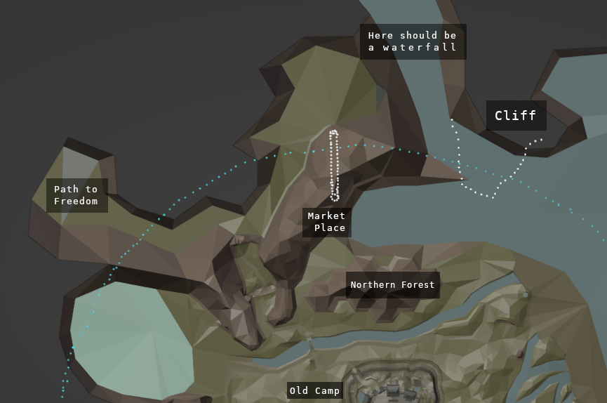
Northeast
Author: Flosha
Written: 15.08.2024 - 14.09.2024
This document contains an analysis of the development history of the entire northeastern environment of the colony as well as our overhaul of the territory in Phoenix based on our findings. Namely we are dealing with the level design of…
- The Cliff of the Damned
- The Exchange Place [EP]
- The Northern Forest
- The Northern Lake(s)
- The Abandoned Mine [AM]
- The Bandits Camp
- The Old Temple Ruins
Definition: As the Northeast we define everything north of the northern river and east of the troll canyon. We are doing so because all of these locations are in some way connected and the design of one of these can not be dealt with in isolation to the others, as will become clear.
Some of the background story of these locations may be mentioned in course of this document in so far as they are of importance for design decisions; but the locations will be dealt with in regard to their lore or their relevance for the story mainly in the other, respective sections of the documentation.
Alpha Research
Origins of the Cliff
What is not yet known and has been overlooked so far by alpha research, is that the idea of the cliff is older than the idea of the barrier. And more than that, we have to assume, that it was the cliff which served (at the dawn of the Orpheus concept) as the first and primary level border. In the Guild System v1, where every guild had its own position regarding a potential escape plan, it is written about the thugs (GRD) that they…
dream to take one night the cliff by storm
This dream implies, that overcoming the cliff would enable them to escape. It also implies, that it was then supposed to be heavily guarded. It wouldn’t take long to the invention of the barrier; in the escape plan position of other guilds in the document, the barrier is already mentioned. But in the earliest notes it was indeed not yet around. In the earliest known concept, described in the Orpheus history, the revolt had taken place (mainly motivated by the threat through the monsters that the wardens did not protect them from) and the royal forces were only able to stop them at the cliff. From then on, the prison was under the control of the prisoners, before any talk of a barrier.
Maps of the Art Director
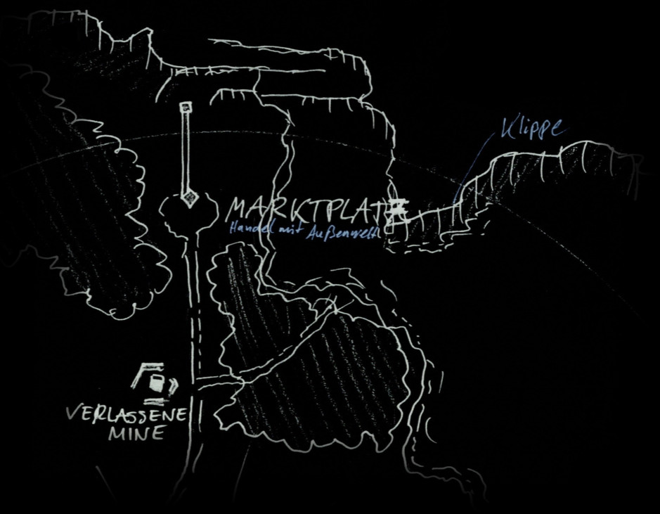
It was defined from the start that the Exchange Place, originally called Marketplace, was directly in the north and on the first known map sketch by Mike the cliff has been positioned north of the marketplace, with a lake below the cliff:
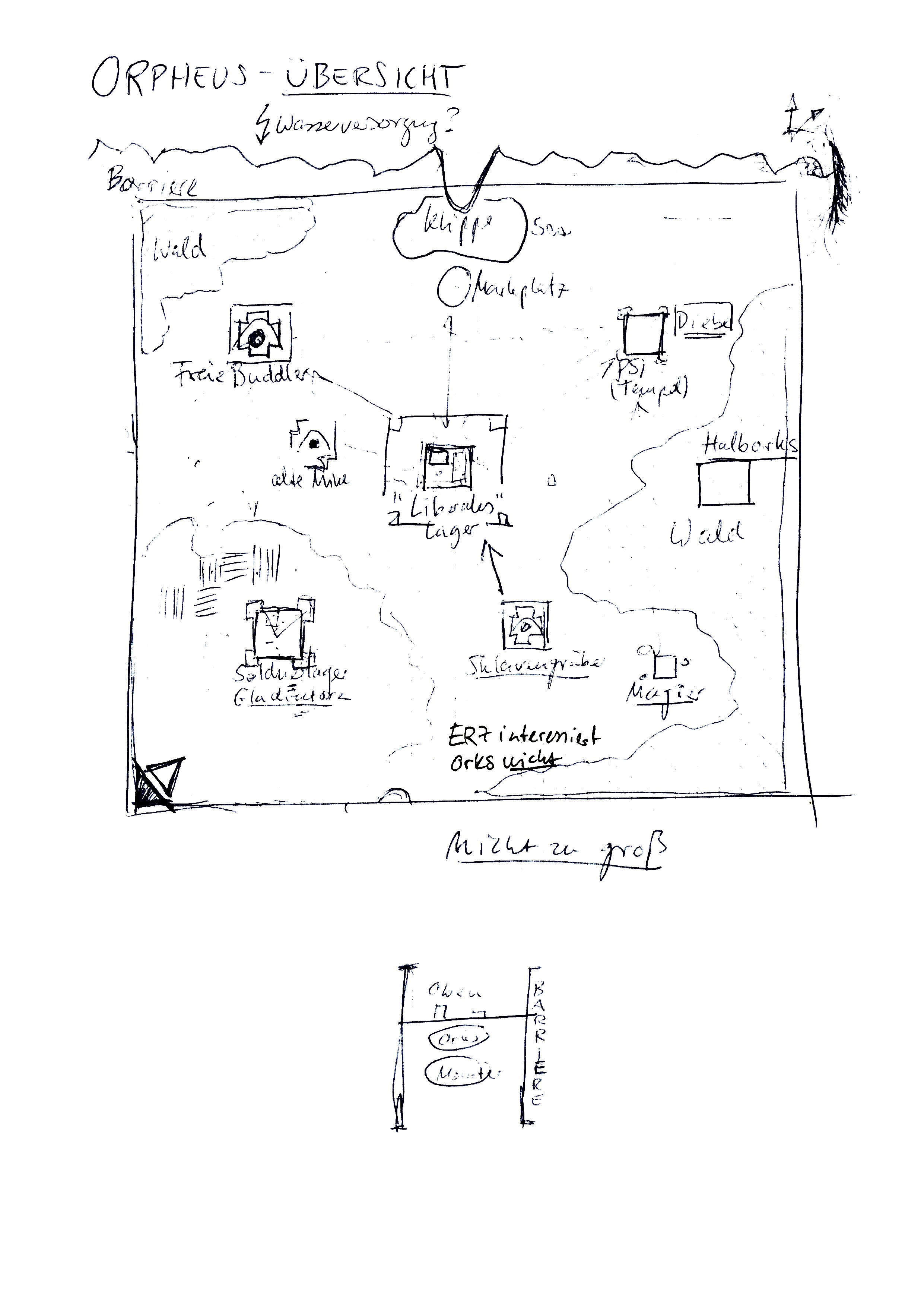
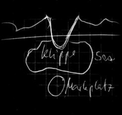
This has then been changed in Mikes much more elaborated “Orpheus Overview Map V1” from 1996. While the marketplace stayed in the very north, the cliff was not directly north of the marketplace anymore, but now positioned east of it. And the water into which the player was supposed to fall from the cliff, which has been drawn as a lake before, was now directly connected with the ocean; it was still between the marketplace and the cliff, but now, like the cliff itself, it was east of the marketplace, with a path in the north (behind the barrier) leading in a serpentine way towards the west.
The scribble by which Mike had signified the marketplace on this map (and on his next map too), may not easily be recogniseable as what it is (this would later lead to a misunderstanding). On the first sight it may look like a big towering structure and I interpreted it as such myself at first, but actually it is supposed to show two ropes, attached inside and outside the barrier, representing the ropeway by which the exchange of the ore from within the colony and the goods from the outside world would happen. The ropeway was thus among the earliest ideas of Mike for the exchange place.
The player was here not supposed to swim towards the marketplace, but towards the so called northern forest, from which a way (as you see it being drawn through the forest) would lead him to the Abandoned Mine south of the marketplace. Alex Wittmanns Gothic Novel was written with this map layout in mind and even the Gothic Comic (2000) has been made in accordance with this idea, where the marketplace is clearly separated from the place at which the convicts arrive.
The two locations where still listed in separation in the level design docs of the Phoenix Concept. The cliff was described as Die Klippe der Verdammnis (“Cliff of the Damned”), as the convicts would be convicted here and damned to a life long prison sentence in the penal colony (some dying in the water). It was meant to be much higher than the cliff in the release version. And from the cliff the player was meant to have an overview almost of the entire colony, as described both in the comic and the novel, where the protagonist could even see the Psi Camp from afar.
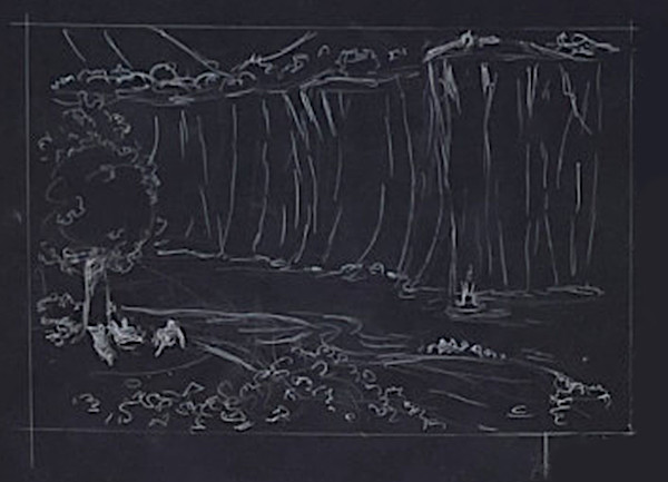
The cliff in the Comic as seen from the edges of the northern forest; a new convict being thrown down the cliff, hitting the water, while the thugs wait for the convict to arrive.
The convict reaches the shore and is welcomed by the thugs, “baptising” him in the cruel tradition of the self-ruled penal colony, witnessed by the four friends.
In his next and the last known map sketch, Mike elaborated his former Orpheus Map further. While the marketplace and the cliff stayed just as they were, the northern lake changed in appearance in that it did now stretch further into the west, but less into the south, due to the introduction of a new river, that would flow south of the northern forest, from the northwest of the colony (it would later become connected to the New Camp) into the sea in the east; this river would remain there till the release version of the game. This change did not affect the gamestart as originally imagined, but it changed the distance to the Abandoned Mine, which was now on the other side of the river, behind the bridge and not so close to the northern forest as it was in the Orpheus Map.
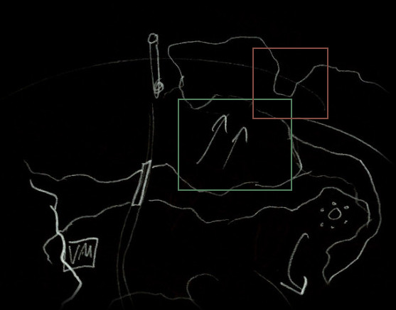
The cliff marked in red, the forest in green; the arrows in the forest mean to connote a rise in the terrain; it was meant to go upwards here - next to it the marketplace. The Abandoned Mine (VM) more south behind the bridge. In the east the originally imagined position of the stone circle is seen.
As already noted above, Mike had signified the marketplace on both of these maps by this scribble of a ropeway, which would be interpreted differently by Ralf, the concept artist.
The Old Temple ruins (Monastery) and the Bandits camp were not yet part of the concept at this point in time and are thus not appearing on Mikes maps.
Concept Art
When Ralf Marczinczik started to draw concepts of the surface for review by Mike, he diverted quite a bit from Mikes original ideas. But for the most part this may have been caused by a misunderstanding, which we will explain further below. On one hand, he has drawn this concept of the “starting location”:
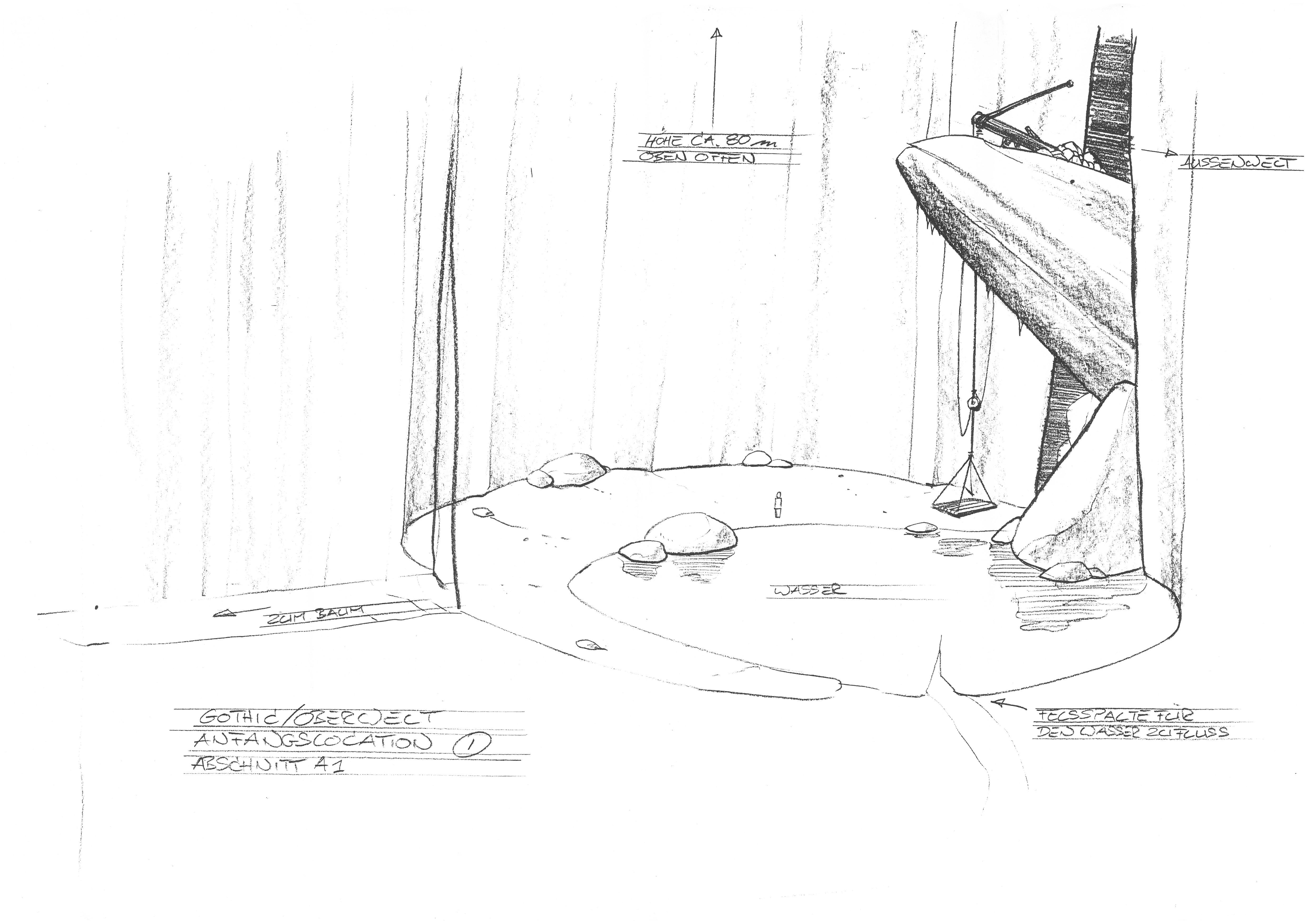
Obviously, this is his version of the cliff. You can see a lake and he thought of an influx of water in the east, which was the opposite of Mikes idea, where this water would run towards the east into the ocean and was not drawn as a separate lake. Ralf thereby removed the water directly in the north of the northern forest that the player was meant to arrive at. Instead of the water there was now a thick mountain wall between the forest and a smaller, separated lake within this starting area with the cliff surrounded by vast rock faces. But he also did draw this:
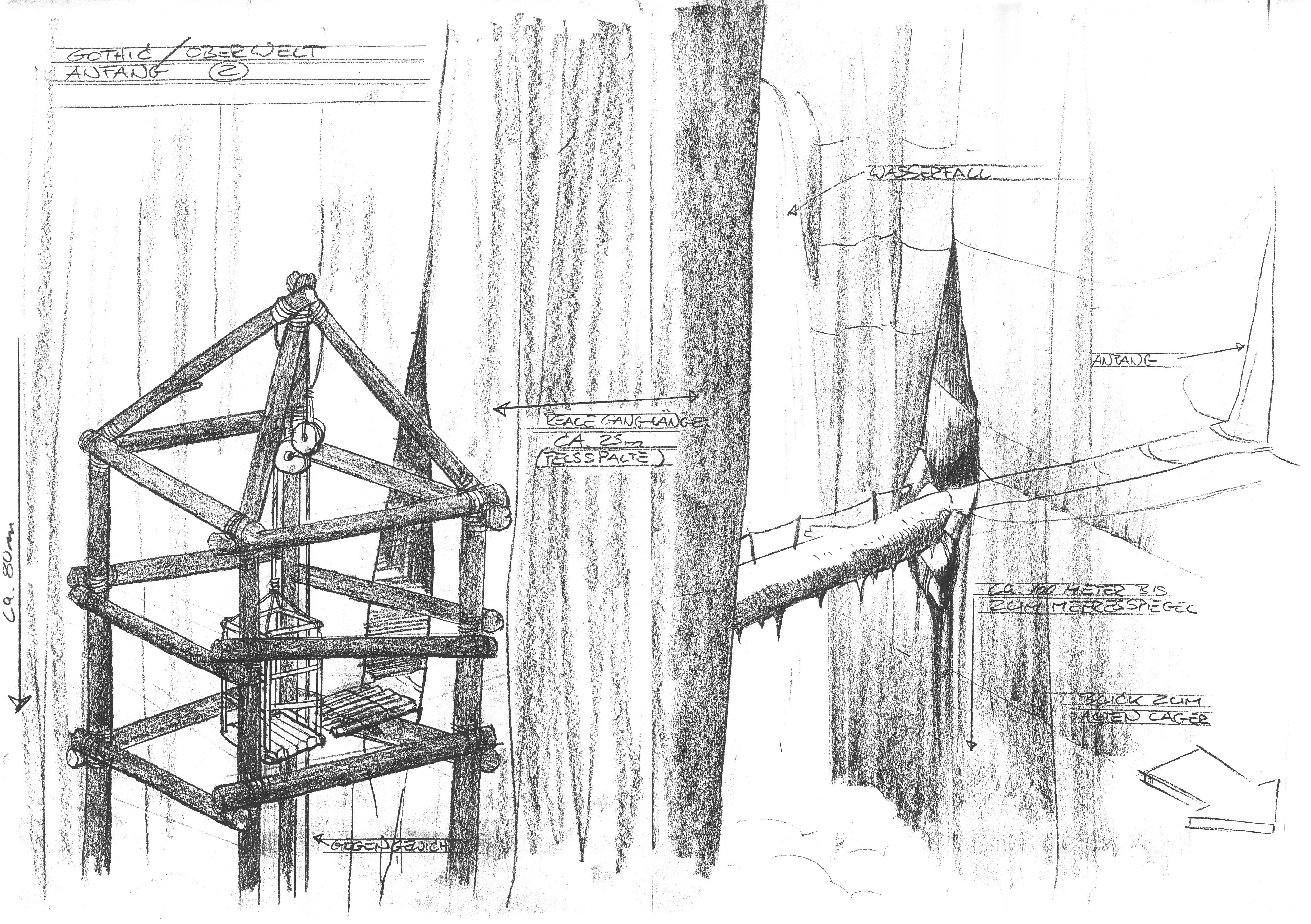
Here the player would walk through the hole in the mountain wall, over the tree alongside a waterfall, from where he would have a short sceneric view into the colony towards the Old Camp. Through a hole in the mountain wall again he would enter this lift, leading 80m down.
The lift would bring him into this area, where he could take a passage way towards the valley or another path leading to the Abandoned Mine:
A path which through the placement of the rocks - which are hiding the passage to the valley from the perspective of the player when he arrives - would have been most likely for the player to take first. While when coming back from the mine, looking into the other direction, the path to the valley would become more obvious to him. Whichever path the player would take, he would leave them to arrive here at the “northern environment”:
It seems that these two concepts, the one with the lift and the one with the higher cliff and the lake, are two different concepts for the players way into the colony, as this second concept is overwritten with “Anfang” (start), and the first one with “starting location” and in both cases Ralf described the way from above towards the valley, as if the player would arrive here.
In case of the lift this must be the case, because the reason that the lift was imagined to be 80m high is that most likely it was meant to be within the barrier at the bottom and outside of the barrier at the top. In this case the player would not have been able to take the lift a second time; as it was a lift for the exchange of the goods. We are very sure that the lift was drawn by Ralf in a misinterpretation of what Mike had drawn at the marketplace, as it indeed can easily be confused to show a sort of towering structure. Ralf interpreted it as an ore lift from within to outside of the barrier. Through a misunderstanding he thereby came up with a new, interesting idea.
The two approaches also cannot be connected, because in the first concept he connotes “zum Baum” (to the tree) as the only path out of this area and we have to assume that with “tree” he is referring to the hangmen’s tree. So he would just walk through this opening in the rock face and then through the forest towards the hangmen’s tree.
Ralf also had not included any noteworthy rise in the terrain (such as Mike had done on his map, where the area was supposed to lead upwards to the exchange place, as it was later realised in the game). Instead of having any organic inclination, Ralf has drawn rather strict straight paths, first horizontal, then a vertical path downwards in form of the lift and again a strict horizontal path to the valley. It is easier to design an area in this kind of way and becomes very complex if diverse inclinations have to be taken into account, as Mike wanted to have them.
But if we assume that Ralf has seen Mikes Orpheus Map before and that he based his concept on it, we also could argue, that he may have misinterpreted the shore of the water at the bottom of the cliff and the marketplace, with mountain walls. The “opening” that Mike has drawn in the Orpheus map to connote that he would enter the forest here from the shore, he may have interpreted as an exit instead from the mountains into the forest. In this case, the following image may make it easier to imagine the layout:
In this case the two concepts above may indeed belong to the same time and show two separate locations; the first concept would show the cliff, which you would exit through a crack in the mountains somewhere behind the forest (red), while the second concept(s) would show the marketplace, with the sceneric view towards the Old Camp (blue) and the exit from the lift (green). But if so and if the player would arrive via the cliff, the player would never have been able to take the lift and see the top; he would never walk over the tree and so forth. Therefore it remains most likely, that these two sketches show two different approaches to the cliff/marketplace; in which case the one that I showed first, may be the later one.
We also have a concept by Ralf of a Gondola. This could as well have been attached to the lift he came up with as to the actually planned ropeway.
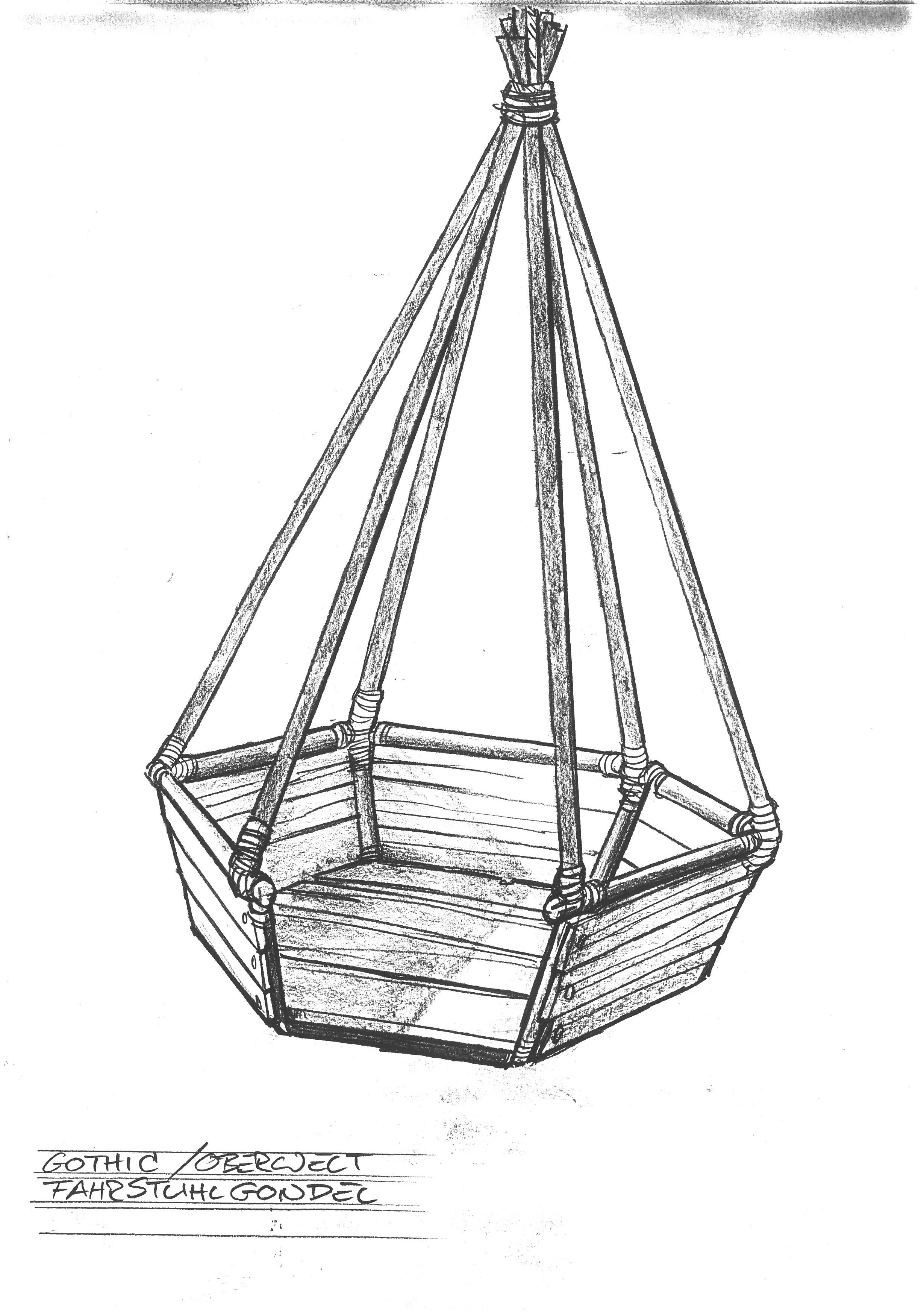
It should be obvious how much these concepts deviated from Mikes conception. And if you look at the second of Ralfs sketches above, you will see how Mike has added some scribbles to Ralfs concept to show him how he wants it to be, although it is difficult to interpret them. It was an usual process for him to draw over Ralfs concepts as a form of feedback to better explain to him how he imagined it instead or how Ralfs suggested design could be brought into harmony with his ideas. That said, he did not seem to approve this particular sketch due to how much it changed his idea.
Interpreting what Mike had drawn unto the draft by Ralf, he basically repeated what he had drawn in his Orpheus map and his final map sketch. It seems clear that he did not want the cliff to be hidden in a deep circular valley, as Ralf had imagined it, as thereby the player would have no view of the colony anymore when standing on the cliff. He also seemed to insist on a position of the cliff in the east of the marketplace and to keep the water between the cliff and the northern forest.
In the first world models in the pre-alpha versions of the game, it would roughly be implemented accordingly.
As for the Old Temple ruins and the bandits camp, they were still no part of the concept. It may be that concept art of the Temple ruins exist, but if so, they haven’t been seen by us yet.
3D Models
Pre-Alpha World Models
In v0.56c we can find surface models from January to March 1999. The oldest model of the surface that we have is from January 4. Here the area in question looked like this:
In the second oldest available model from January 22, the forest was reduced in size and the Troll Canyon was added into that pass area. In the latest model available in v0.56c from 1th March, basically nothing had changed from the model in January 22, but they had replaced all the old forests with mountains in the new octagonal shape, since Mike had envisioned the new forest system, where every forest would be divided into such octagonals like a honey comb (this system was introduced here and used till the release). The mountains were never meant to replace the forests, they were placeholder models for the new forests to come.
In this version of the map, it is unclear where the Abandoned Mine was supposed to fit. Most likely it was meant to be directly below the exchange place alongside those mountains, as done in later versions too. It may look as if this wouldn’t fit there, but the proportions of the map are misleading, since the placeholder structures beyond the barrier are so huge that they let the area within the barrier and around the marketplace look small, while actually there is a lot of space there.
The old temple ruins and the bandits camp did not yet exist. The entire model was done very roughly and around the camps (which were already much more elaborated, with the Old Camp almost final), in order to get an idea. Most of the model should be interpreted as nothing but a “dummy” and in some cases, it is even named like that (such as the “dummy meer” (dummy sea) or the mountains). A lot of things were bound to change, but at least it had managed to preserve the overall layout of Mikes concepts.
Alpha World Models
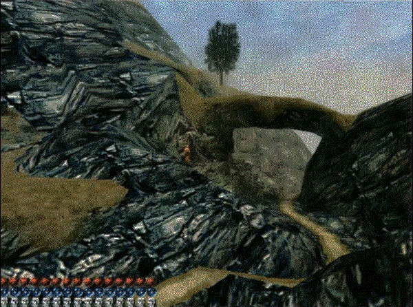
In about v0.7, the surface was actually modeled out in a huge update of the world into an overall shape that it would keep until release. The whole mountain terrain in the north was now modeled with a very steep rise in the terrain. The exchange place looking like this:
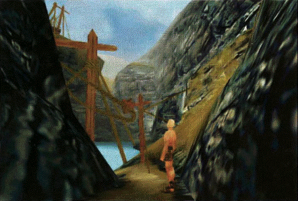
It is here, that for the first time the ropeway appears, that players would know from this screenshot and the gameplay video of the PC Action and would anticipate to be in the game. Later it would be removed and replaced by a much less iconic and much smaller lift.
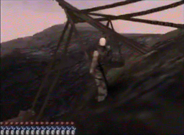
The ropeway in the PC Action video.
At first the lake at the exchange place was simply designed as a lake in a basin of mountainous terrain, with no room between the lake and the mountains. There was not meant to be any kind of storage or a camp here and there was also no room for it. Only (in another sub-version of 0.7) a wooden platform has been added that the convicts could stand on and handle the exchange alongside a platform above that the royals would use.
The convicts would come here once every month, receive their goods from the outside world and deliver their ore by using the gondolas on the ropeway, then bring the goods to the Old Camp. In the Comic this process is shown in connection with a carriage and horses, but still - there is no storage here and no reason for it.
Accordingly there also was no gate to protect the exchange place, as there was nothing to protect (other than the ropeway itself); there was no ore here obviously, as it was all delivered outside and there were no goods from the outside world here either, as they were all brought to the camp. In the initial concept, members of the Free Camp were also meant to use the exchange place (e.g. at night; if with or without the knowledge of the Old Camp), so it was not meant to be exclusively used by the OC. The members of the Union were meant to be protected by Templars, for their protection the Union would give them drugs or necessary ingredients, one of the things they would exchange their ore for; the New Camp of course would not be involved in this at all, as they refuse any kind of cooperation with the Outside World that they hate.
The other side, view from the exchange place towards the Abandoned Mine area.
There would be no gate here till around v0.94k.
In screenshots of v0.8 to 0.9 it is still not included.
The screenshot also suggested orcs to arrive here. An idea that may not only have been set up for the screen, since the orcs occupying the exchange place is an idea that traces back all the way to the earliest Orpheus notes.
The actual reason to protect the exchange place and why the gate may make sense would have been due to the New Camp, which could have a strong motivation to destroy the ropeway in order to stop the exchange with the outside world, which is their primary enemy; but there was obviously nothing to rob - nothing but the convoys.
A Hole in the Mesh
On first sight it may be seem very clear, that the world of v0.7 has alread merged the ideas of the exchange place and the cliff. But as we do not have a copy of this version of the world we cannot say so for sure. In course of months of reflection about the area I found at least a few hints and a possible explanation for how the separated cliff could actually have been implemented in this version of the world.
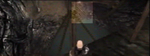
For a long time it has been speculated what the big hole in the mesh was meant to be that can be found on the plateau above the entrance to the Abandoned Mine. In later versions this is covered by rocks and there is nothing behind.
If this passage was just meant to connote some collapsed mine, it would not have been modeled the way it has been. In case of any other area in the world, such a collapsed passage way was closed, but this passage was open. It was simply a hole in the mesh, thereby clearly telling us that either there should have been modeled something more here later or that something was removed here that was there before.
It was therefore mostly speculated that it may have been an original, bigger entrance to the Abandoned Mine, although we have nothing supporting this idea other than it being close to the mine.
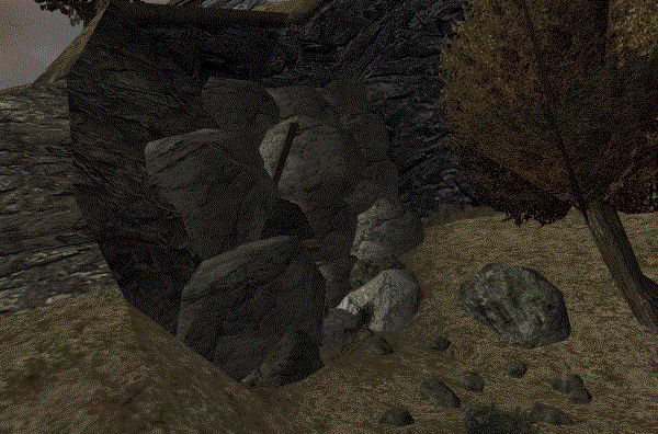
On October 28, 2023, I got the idea, that this passage could actually have been - or has been supposed to become - the realisation of the cliff, where the player would have fallen into a lake separated from the one at the exchange place and swim out of the lake to exit this place through a passage in the mountain wall. (Although it took me almost another year to arrive at a full picture for a potential design, as described in the Phoenix section).
While this is not exactly how Mike may have had envisioned it at first, it is exactly how Ralf has drawn it - and we know that Ralf was fully aware of the hardware limitations and that he made his concepts with this in mind. He always tried to offer solutions on his concepts how to realise specific ideas inspite of the technical limitations, often rather underestimating what the hardware would be capable to do and staying on the safer site. This is the very reason that all of his locations and his whole colony design is so much surrounded by huge mountains running almost vertically up, isolating many of the locations. It was for reasons of rendering. The actual level designers have taken these concepts as inspiration but took the freedom to model the mountains more organically, as it was sufficient to block the view port.
Due to the technical limitations at the time it may have made sense to put a mountain wall in front of the lake; the cliff could still hover past it. The mysterious hole we speculated about for so long could thus actually have been the place through which the player should exit the lake to arrive on this plateau; where, when the early concepts would have been followed, the northern forest should begin, which would then have been in accordance even with Mikes old Orpheus map, where the cliff is in the east of the exchange place and where the Abandoned Mine and the path to the exchange place is running along at the west of the forest. But the idea that the northern forest could actually be here, so high up, just didn’t dawn on me earlier than in these days of writing the documentation.
It remains speculation. We do not know if it was ever implemented like this, but we consider it to be the most likely explanation for the hole in the mesh. It may have been discarded before realising it, opting for the later solution where Cliff and Exchange Place are combined. This may have happened because the model of the exchange place, that may have been done first, was so well received that it seemed like a good decision. It may have been due to technical reasons, as the entire colony overview through the separated cliff might have been too much; we don’t know. But we know that in opposition to how it may seem at first sight and inspite of the many differences to the very early (dummy) pre-alpha models of the world, the idea of a separated cliff could be realised in the 0.7 model easier than one might imagine - while the combination with a northern forest and the connection to the sea remain difficult to solve and seem indeed to have been discarded at this point.
The positioning of the now combined cliff and exchange place, as far as we know, did not change from here on. The cliff was slightly higher than in the release version, but in both cases the player was unable to see the colony. All the ideas regarding the gamestart with the northern forest (which itself was also removed completely) and the cliff as a separate location, where thereby discarded.
AM in 0.7-0.9
The Abandoned Mine did now find its place in the world in 0.7 for the first time. Originally the entrance may have first modeled only on the right (in the west), as seen here:
But it could be as well, as the second screenshot from the same or a similar version shows, that it may have just been this west side of the model that was looking differently at the point; in a sub-version we can see how the east side of the mine has already received its final design:
While very little of Ralfs visual ideas for the exchange place (and for the Abandoned mine) remained (other than getting rid of the water connected to the sea, which does not seem to have been Mikes intention), we could very well interpret the bridge that was added to the Abandoned Mine, connecting its east and west side, as a later version of Ralfs tree between the cracks in the rock faces. Just as in Ralfs idea, the player would have a very sceneric view of at least the Old Camp from this position.
Alpha Path into the Valley
While in the earliest pre-alpha models all the terrain had been completely flat, similar to how Ralf had drawn it, the rise in the terrain in this model (which Mike had suggested on his sketch) was now so steep, that it made it hard to believe that any kinds of wagons could be drawn up this path easily. And certainly not by humans. But that was not necessarily a problem, as in the game the convoys were meant to happen by convoy ‘carriers’ carrying the ore sacks on pack baskets on their backs.
This screenshot shows the path up to the exchange place in v0.7X. It did lead from the Abandoned Mine down and through the mountains, ending roughly at the position where later Drax and Ratford would be placed.
Here as well as on a number of similar screenshots you can see how there was no path yet at the outside of the mountain wall.
On this screenshot the original path through the mountains (instead of at the outside of the mountain wall) can still be seen in the background.
These details about the original path to the exchange place as well as many other differences in the development history were found by us, namely Dmitriy, Vaana and Flosha, in course of years of research in between 2015 to 2018, long before we did have any access to alpha versions containing said world models. As mentioned above, some of them we still have not received any copies of.
Whether or not the bandits camp did already exist at this point, we do not know for sure, as no screenshots exist, as far as we know.
Old Temple Ruins
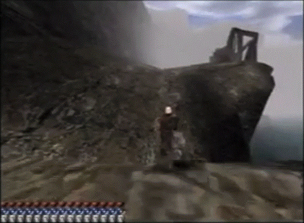
With about v0.7, the Old Temple ruins were implemented, of which we do not have any kind of concept art. We do not know if Ralf has ever drawn anything regarding it. It was added to the world later. But at least far earlier still than the Mountain fortress, that only came in the last few months. In the original design, the old temple ruins were hovering at a cliff over the sea, in very mountainous terrain:
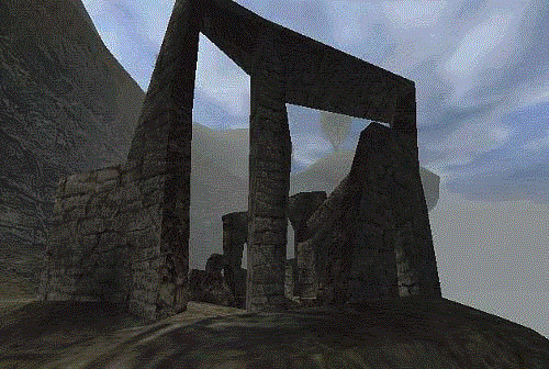
The iconic ruins stayed in the game from v0.7 till v0.9, when for reasons unknown it was replaced by a much less coherent model. In the old model one could actually imagine how this structure has once been looking before it broke down. The entrance, the large gothic windows, the basement. Some thought went into the model and it was very gothic in style. It would be very helpful to find concept arts of it.
It was just quite “open” and the player would have been able to enter it early (although the zombies residing there would have done their best to prevent that) which may not have been fitting for what they wanted to do with it in the new, greatly simplified version of the story. But we will not deal with the question here what these ruins have or may have served in the old story; this will be dealt with in the respective story documentation.
Final World Model
- The ropeway was removed and replaced by a much smaller and more mechanical lift.
- The cliff was reduced in height.
- A sort of camp and storage was added to the exchange place as well as a gate to protect it.
- The original path from the exchange place was removed and replaced by a path at the outside of the mountain wall, which made sense at least from an aesthetical perspective as it offered the player a good view into the valley.
- The Old Temple Ruins were removed and replaced by the new Monastery Ruins.
Summary
The Northeast has changed a lot in course of development. The ingame implementation lost several of the early ideas:
- There was no longer a connection of the water/lake below the cliff to the sea, nor was there any waterfall or any other influx or outflow of the water. This affected the overall atmosphere as well as the believability of the terrain, giving it a less organic and less “wild” appearance than it could have had.
- The connection to the northern forest was lost - and the northern forest itself has been removed, inspite of its dominant role in all map concepts, pre-alpha models and the novel, where the Abandoned Mine has always been imagined close to a forest; and an early forest exploration (of course a less dangerous one for the start of the game, which makes sense due to how highly frequented it is) would have served the gothic atmosphere well.
- The player could not see the colony from the cliff, as it was initially planned and described in the Comic and the Novel; although a similar sceneric view was offered later on the bridge, the original view from the cliff itself, from where even lights from the Psi Camp should have been seen, was lost.
- The later implemented cliff at the exchange place was very low in comparison to the originally imagined cliff, which was meant to be higher and induce more fear of the fall.
- Another aspect connected to that which also has been lost and which follows from the inability to overlook the colony from the cliff, was that the cliff could hover menacingly over the valley like a memorial to remember everyone of their brutal conviction.
- The ropeway that has always been planned by Mike - and was implemented well in v0.7 - has been removed in the release version; and while the ropeway may have been a more believable solution for the exchange place than the lift by Ralf, the idea of the lift was thereby also lost.
- This also affected the design of the Abandoned Mine, which was discarded in the form that Ralf had imagined it.
Phoenix Solutions
Flosha, 12.09.2024 - 14.09.2024
I want to clarify at first, that I did not want to get rid of the general design of the terrain of the exchange place and the Abandoned Mine from the Alpha versions, as the design of this terrain is both very good and it is the only and thereby the first and last ingame implementation of the exchange place and the Abandoned Mine.
And it is a viable question to ask, as to why the cliff should be separated at all and in which sense that would make it any better. Apart from the dominance of the idea in the concepts and design documents, that give it a high priority according to our principles of reconstruction, one should keep in mind that a separate implementation of the cliff was meant to go along a separate section of exploration at the gamestart; the player would enter the valley via a different path through the northern forest, with different things to explore, different perspectives to discover and additional stories to be told, as they are mentioned in the Gothic Novel, while the path to the exchange place wouldn’t be lost, but still be there and explorable in addition to it. It is in this way that it would be an improvement. Apart from all the interesting interconnections, possible interactions with the convoy and so on. Other than that, in the old story the player would have a reason to visit both the cliff (arrival of new convict(s)) and the exchange place (new convoy) and the AM again in course of the story, thereby approaching the paths from the other direction; all of which did not play a role in the heavily trimmed story of the release version.
Exchange Place
At first I reconstructed the iconic ropeway from v0.7, which Mike had envisioned from the very start and which is not just a visual improvement or a change motivated by nostalgia, but the way that the ropeway is setup also makes it more believable that it was constructed after the creation of the barrier in a joint effort from within and outside the barrier by pulling and pushing the central pillar up, stabilised by thick ropes; it simply makes sense based on its construction. Remodeling it was easy enough and did not involve too much effort. By doing so I realised that the rock faces on which the lift has been placed must have been higher in v0.7 than it was in the release version and adjusted it accordingly.
I then thought about how, while preserving the above mentioned terrain and setup, I could at the same time include…
- a potential separate cliff with another, connected lake and how this lake could have a connection to the sea.
- the northern forest (connected to that lake at the cliff) and…
- the ore lift in combination with the Abandoned Mine Concept Arts.
And especially: How I could realise all of this inspite of the Old Temple (Monastery) Ruins which - at first - seemed to be very much in the way of these intended changes.
Northern Forest
First Approach
[modeled in 2022]
The northern forest I had first implemented in a smaller form by changing the terrain in the north of the river but almost without touching (or relocating) the mountain terrain leading to the AM, which I thought was way too much work to pull off. This way the forest was not connected to the Abandoned Mine - I tried to solve this by including a second, lower entrance at the bottom of the mountain instead. And in order to make this forest more special I came up with a tricky hack by which I could let a side stream of the river flow “through” the forest - or at least create the illusion that it does -, which is very problematic from a technical side.
This way I realised a forest in the north without any need to change much of the mountain terrain leading to the exchange place. I did spend at least 50 hours on this solution. But the forest was much smaller than the one known from v0.56c and v0.64b and there was no lake. I had a forest in the north now, but had realised almost nothing of the initially conceived progression of the player that should arrive here from the lake. In the end, the work was mostly in vain.
Second Approach
[modeled in ~Nov 2023]
There simply was no space for the northern forest and the lake, as the mountain range began immediately behind the river. But when compared with the release version, in the pre-alpha models of the world the northern environment did stretch further into the north.
So I discarded my first attempt and decided, that in order to implement the forest in its full size from v0.64b as well as the lake behind it, I simply could not avoid to shift the entire mountain terrain that leads up to the AM and EP further into the north, as there was simply not enough space. I was very reluctant to do that, as such a translation means that all the objects (Vobs) had to be brought over to the new position (the gothic modding community has written a fiddly tool for such a case, but it is a very large area and I had no experience with the tool). In general it is my approach to avoid any unnecessary changes. But in this case, it just seemed necessary.
So I translated the entire northeastern terrain on the global Y axis (+200) to create additional space where the forest and lake would fit.
In this solution, the forest had the same size as in the pre-alpha builds and so had the lake that was to be connected to the sea. But then the mountains were still there and in the way; after all, the cliff was meant to be here north of the lake; but now a large mountain range was north of the lake that was leading to the AM and the Exchange Place. The forest and the lake were still completely disconnected from the northern terrain and the level of the water at the lake was exactly as in the pre-alpha builds, not much higher than the sea, because I hadn’t yet realised the intended rise in the terrain.
In course of this approach I modeled a cliff exactly where it was apparently meant to be according to the dummy models of the pre-alpha models. But then he would fall unto mountains… So I did let the lake run underground into a sort of cave in the mountains. The waterfall from Ralfs concept art was falling into this cave. The cave was partially open at the top so that the player could fall into it (but it was way too high. 60 meters, if I recall correctly, although such a fall does not seem as high in third person). He would then have to swim through this cave through a cleft in the wall and towards the northern forest.
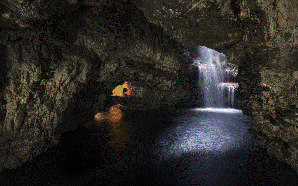
Photos like this one served as inspiration for this “waterfall cave”.
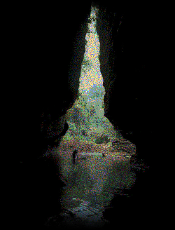
This photo served as an inspiration for the exit out of this cave; the player would have to swim through an opening in the mountain wall that I modeled inspired by this photography. It actually would have been very atmospheric.
Since the lake was on the same level as it was in the pre-alpha versions, it had to somehow flow around the Old Temple (Monastery) Ruins that were exactly inbetween the lake and the sea. Should I now try to relocate them too? I preferred and tried to keep the ruins at their original position and let the water from the lake behind the forest flow around it and down into the sea. At least in the north of the temple the terrain even seemed to suggest such a potential use. But it also meant that I had to remove the entire mountain wall west of the monastery, as well as the mountains north of it. I did so. And it could have worked, somehow. But I was not satisfied, as it seemed like a compromise. The opposite of our uncompromising design approach.
This screenshot shows this second approach of mine; you can see the cliff here, next to Ralfs waterfall idea that was actually leading to the ore lift and the Ruins in front, now without any rock faces west of them, the lake running past it.
It got rid of some of the desired atmosphere of the temple while at the same time corrupting the desired atmosphere of the lake and the water that should flow down there. Instead of improving upon both, it made both worse. Which is why I started to contemplate in earnest about a possible relocation of the Old Temple Ruins.
What I totally miscalculated with this second approach were the proportions. I designed it all based on maps and views in Blender and as if the proportions of the lake and the position of the cliff in the pre-alpha builds would be reasonable to follow. When testing it ingame I realised how much bigger all of this was than I imagined it to be while looking at it in the 3D programme. The northern lake in the pre-alpha versions as well as the suggested position of the cliff were of course nothing but very rough dummy models, but they also had heavily exaggerated proportions. It was not a viable approach to orient myself at them for the design of the territory.
It was all very made up. Due to the proportions the lake was so big that the player would have to swim a long time towards the Northern Forest, and that just for the pre-alpha lake; with the underground section it became an even longer swimming section and all of this made it less believable. In the original concepts the player was meant to fall from the cliff and the thugs at the shore should have seen him and one should be able to imagine that they would even be able to fish him out of the water if necessary. This approach realised nothing like that.
What this approach also missed based on the pre-alpha model, where everything was still flat, was how actually the forest was meant to be part of the rise in the terrain towards the cliff. I missed this completely based on the pre-alpha model that I considered as more final than it should be considered as, and Ralf had apparently missed this too, as on his concepts the forest is also presented as a very flat area. While I liked (and I still like) some of the ideas developed in course of this approach, they weren’t lost. The idea of the underground waterfall cave could still be realised; it just hadn’t have to be in the context of the Cliff.
All of my problems with the Old Temple Ruins I had could have been avoided when realising this and the implications of it earlier.
Final Solution
[modeled in ~Sep-Oct 2024]
Now I had implemented the forest already twice, in two different approaches and a lot of this work has been in vain.
My approaches were too isolated. The entire northeast had to be looked at as a whole, but I couldn’t, it was simply a task too complicated to comprehend and sometimes it seemed impossible to solve. Therefore I opted for viewing single aspects of the northeast in isolation, such as the forest and the lake. A real solution, if it would even be possible, would have to take everything into account. Therefore I decided to stop any further experimentation and considered a more thorough analysis as the priority, which this document is the result of. Only through the deep analysis in the document at hand I realised how I could actually solve these design problems and combine all of the desired ideas.
I could solve it by the revelation in regard to the hole in the mesh above the AM, how that could be connected to another lake, which I could connect to the one at the exchange place, and how the plateau behind that passage could thus be the actual point of arrival and the place where the northern forest should begin, that should be part of this terrain leading down towards the river, and not an isolated, flat forest at the bottom of it.
I realised, that when I thereby followed the concepts more radically, I would not even be in need to make more room (at least not as much) between the river and the exchange place due to the forest and the lake, because it was not about realising them in seperation to the mountainous terrain towards the Abandoned Mine, but as a part of this terrain.
The forest itself could already begin on an elevated surface and did not have to be so low and close to the river, as it had been done in the dummy models of the pre-alpha builds; it could be higher. And when the forest would be higher and rise up towards the cliff (as Mike had suggested on his last known map sketch), I would potentially be able to even out the very steep path towards the mine a bit, distributing this rise more evenly.
The forest would reach to where from at least 0.8 onwards there was the plateau in the northwest of the Abandoned Mine; this plateau and some mountains is basically the only thing that would “disappear” in this form; or perhaps not even that; the forest would be either covering it or begin immediately south of it. And then reach all the way towards the river north of the Old Camp. So the forest would rise “towards” the cliff, the mountains inbetween (right of the path to the exchange place) be transformed into the forest, a more even inclination introduced, which would only improve the believability regarding the convoys as well as the atmosphere and really get close to the old concepts without loosing anything of what was essential about the terrain as realised in the game from v0.7 onwards.
We should imagine the path alongside the AM towards the EP and the path through the forest towards the Cliff as two seperate paths that run parallel to each other, with height differences and one or two connections, such as the place where you can climb up to the plateau. That said, I was not actually in need to reshape the terrain of the plateau; it could remain the elevated area that it was, within the forest, thereby making the forest just more interesting and creating additional sceneric views into the colony. The forest didn’t have to run down into the valley in one even decline, but it can do so in steps that I would connect via serpentine paths. And more so: While the path to the exchange place would be the original path through the mountains known from v0.7-0.9, I could actually reuse the path of the release version too that ran down at the mountain; it just would become a path within the forest; perhaps without even a need to relocate it. Just the mountain behind would be changed or heavily reduced in size, becoming a part of the forest.
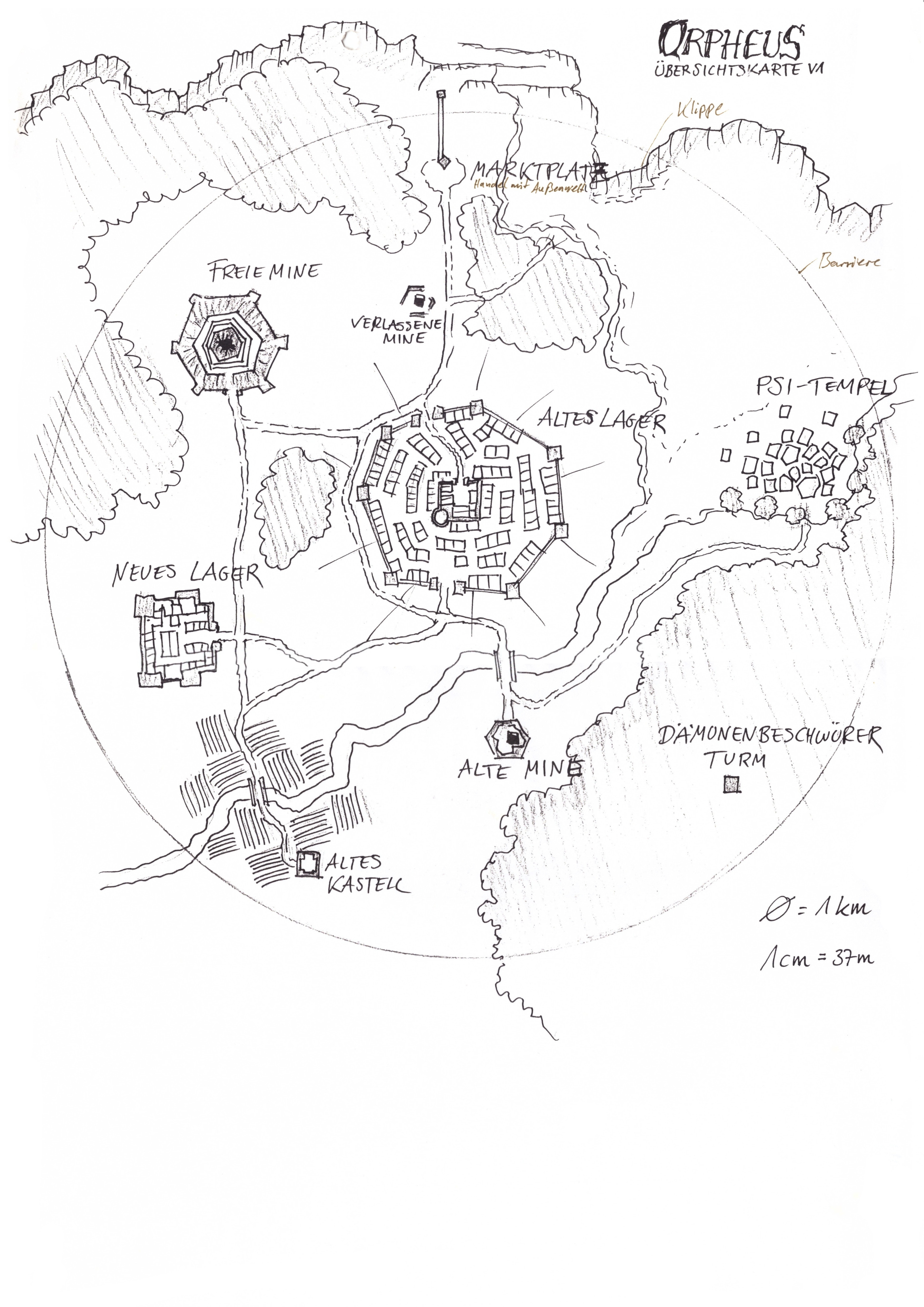
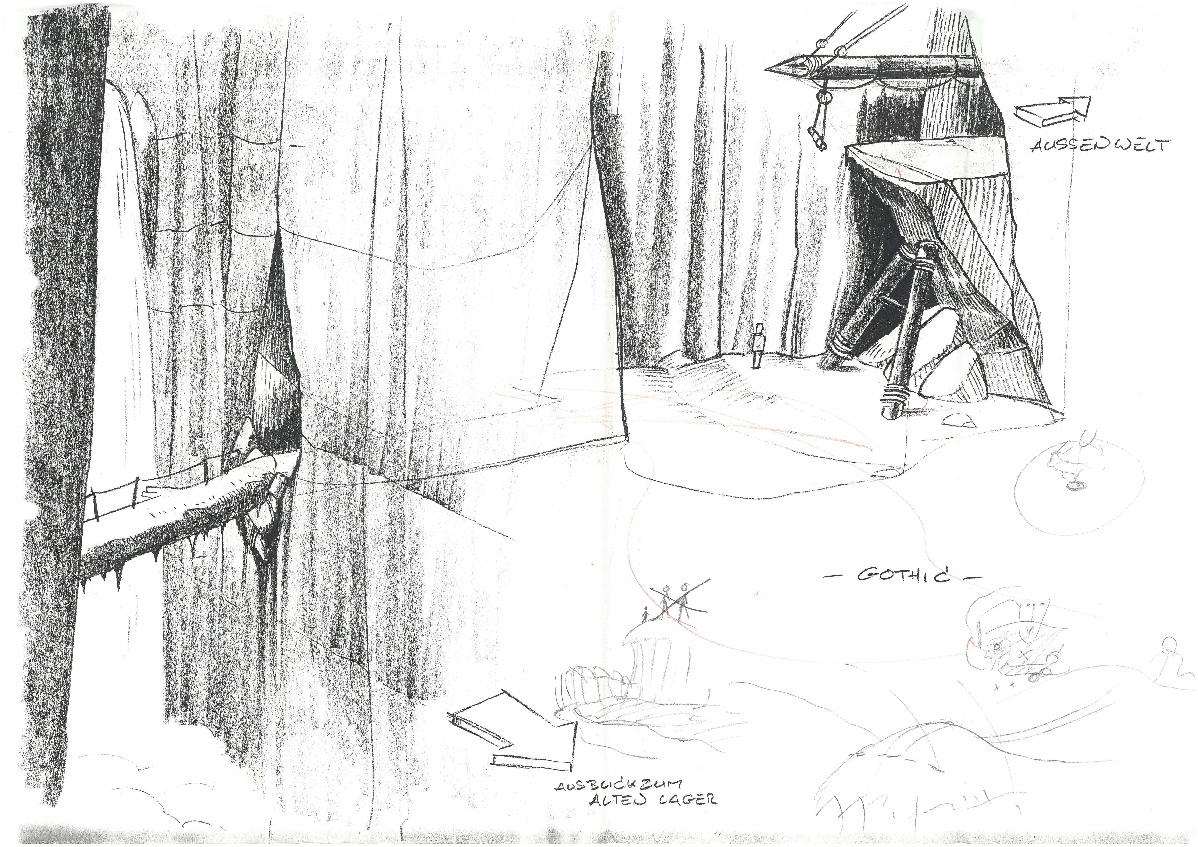
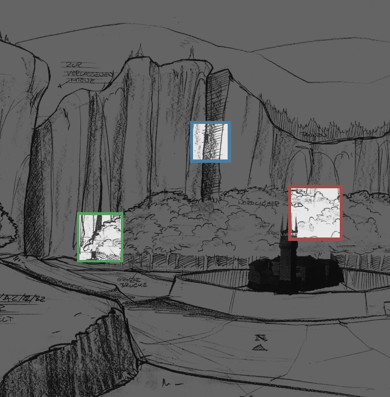
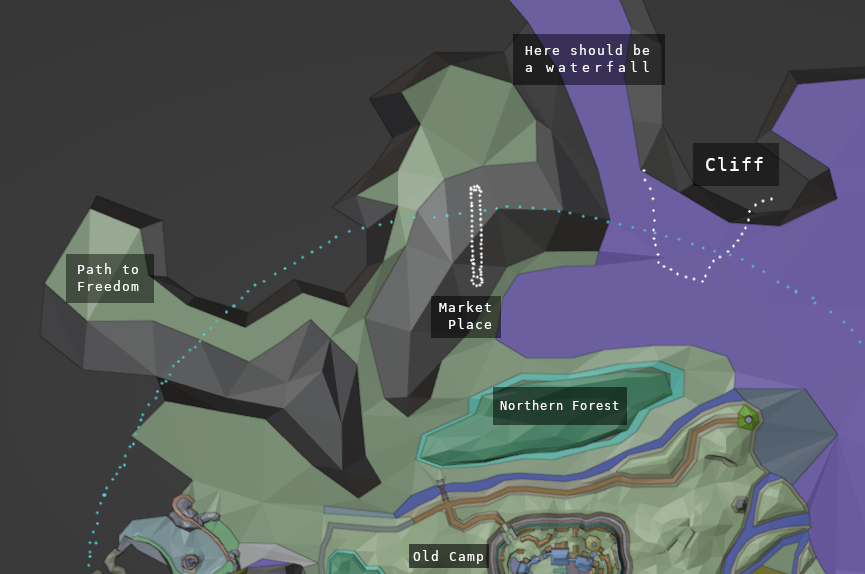
The Cliff
As originally imagined by Mike in all of his sketches, we could now have a Cliff seperated from the Exchange Place (EP) and in the west of it, while the terrain would still be connected to it via the lake and the mountains. The cliff could be placed high enough to have a view over the entire valley including the Psi Camp (and the EP too); it would be higher than it has been realised at the EP later, but not as extreme as I had done it in my second approach based on the pre-alpha dummies.
With the Cliff and EP separated and when the people come from the west (which the early maps and the dummy path in 0.94k is suggesting), bringing a convict to the Cliff means going a slightly longer way. While not being of relevance for our first act, it becomes relevant in the second, when the player can reach this terrain outside of the former Barrier. The path to the Cliff should thus be connected organically with the path to the ropeway and should really emphasize the impression of an official path to conviction. This impression can potentially be improved by including a set of stairs.
By implementing the Cliff behind the hole above the AM, the view from the EP would be the same as known and its position preserved; from the EP you could see the cliff and vice versa.
Northern Lake(s)
There would have to be a waterfall here, perhaps higher up in the mountains east of it, because based on the height of the hole in the mesh, the water level at the separate Cliff would have to be higher than the one at the Exchange Place (EP); thus the waterfall had to be east of the EP, flowing into the northern lake at the cliff and from there into two directions - east into the lake at the EP and west, organically in form of several steps and waterfalls, down towards the sea.
That this water cannot be at the exact same height as the ocean itself and has to flow down in some way and at some point or another, we can consider as something that Mike had to have already in mind (not in the Orpheus map, but in his final map sketch, where he marked the rise in the terrain), because as the forest terrain was supposed to rise north, it would rise quite a bit up compared to the ocean and the river south of it (that also flows into the ocean), while the water north of it was meant to be not too much lower than the forest, since the convicts should arrive here at the shore.
The forest being at least a little bit higher than the level of the lake north of it makes sense and is something that I had already considered in my second approach, because thereby I could steer the way that the player can exit the sea through the level design. As he then could not swim towards the right (east), nor to the west (where he would fall down the waterfalls) nor could he exit the water at any other point of the forest and thereby avoiding the thugs awaiting him - this way through the design of the terrain I could make sure that the player is forced to swim at this very bay and not anywhere else; since our gamestart could not be introduced by a cutscene, as there are none; the player would “play” the conviction himself and had to swim on his own.
Now in this final solution the forest couldn’t cover the east of the lake anymore as the EP would be here. And based on Mikes concepts I wanted the lake at the EP and the lake under the Cliff to be connected; so there had to be a different way to prevent the player from avoiding the thugs. In the same way I also had to think about what would happen when the player would just swim towards the waterfalls instead… but the specifics would spoil a bit too much.
Abandoned Mine
With this solution the path along the Abandoned Mine would still remain as is. It would be the path as drawn on the earliest concepts, leading from the EP to the camp at the eastern edges of the northern forest (possibly in a less steep way). And the Abandoned Mine too would then be in the east of the forest, as in Mikes Orpheus map.
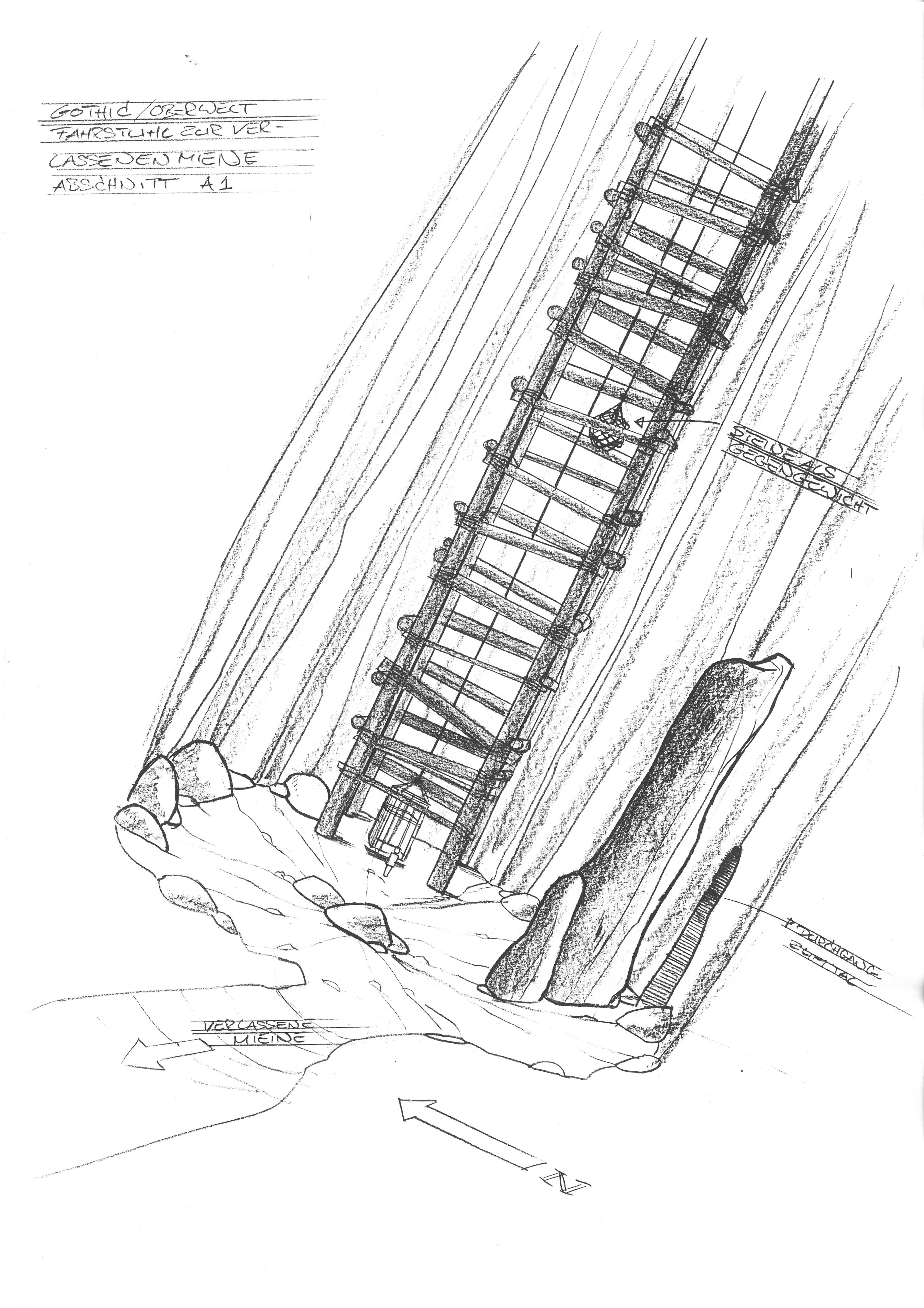
As for Ralfs concepts of the mine: The mine was here basically drawn as a path, with rock faces left and right, some broken houses and additional clefts in the mountains leading into the mining sites. Judging by his concept of the lift, where the cardinal direction into the north is marked and an arrow towards the AM points to the left, it seems to suggest a position of this AM passage in the west of the EP, southwest perhaps, and leading westwards too.
Now, in Ralfs concepts, this path is positioned much lower, 80m to be exact, than the cliff, which is not the case with the Abandoned Mine area from 0.7-0.9 that we keep. But just as the Abandoned Mine we know is not just one site, but a collection of several mining sites on both sides of the mountains, the area already suggests, that the Abandoned Mine as a term is the name of an entire terrain of mining sites. That said, the area from Ralfs concepts can very well co-exist to the area as it has been implemented, somewhere deeper down. It would just increase the area and serve as additional territory to explore.
According to the concept the lift would be placed close to the EP. While the lift may be Ralfs (wrong) interpretation of the ropeway, which serves this concept of exchange already, the lift didn’t really have a reason to exist. But as I just liked the idea and do not want to get rid of the concept, I still decided to include it. And since it doesn’t have to and shouldn’t be used in the same context as the ropeway, it just could be used in a different context.
And by the way, something akin to this ore lift by Ralf, with a counterbalance as a mechanism, is also mentioned a few times in the Gothic novel, by which the protagonist can leave from a dungeon deep down very fast - an idea which we should absolutely utilise in the game at several locations in order to make the backtraveling from all the dungeons easier. Since according to the original concept the Orc Caves will only be accessible by first going through the mines, the temple again would be below the Orc Caves and so on. The player needs to go through all of these dungeons to reach the deeper levels, and Alex Wittmann in the novel, knowingly or unknowingly, has provided us with an actual useful gameplay mechanic to deal with this. An important puzzle piece in the metroidvania-like underground design I am going for.
It may not connect the Outside World to the Colony, as the ropeway is doing so, but it can still be a sort of ore lift and it can even appear at the “same” location, or to be more precise rather the “equivalent” location in the layout as implemented from 0.7 onwards.
Since, as mentioned further above, we can interpret the bridge that leads to the other mining sites in the west of the Abandoned Mine, as being a later version and realisation of the concept art of the tree in front of the waterfall that would lead to the lift, we ought to implement the lift somewhere behind this bridge.
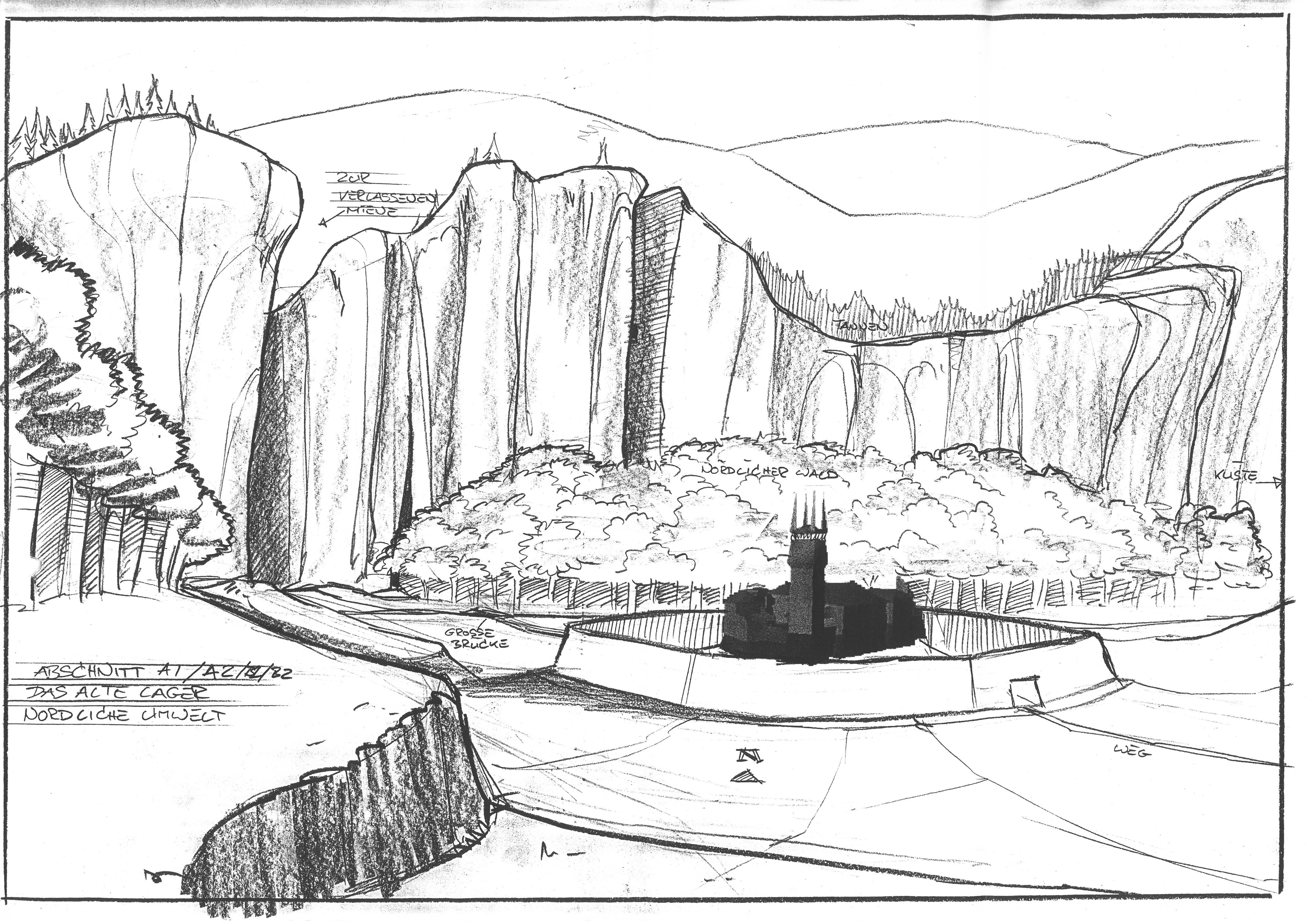
Such as behind one of the blocked mine entrances (one of which may as well be just a passage way through the mountains). And if so - what is on the other side of the mountain? Quentins camp, the supposed to be hidden camp of the rogues, renegades from the New Camp. And where is it in relation to the EP? In the southwest. A perfect fit.
Quentins Camp
Quentins Camp was a highly underdeveloped location, which was implemented late, did not serve any purpose in the story and had almost no environmental storytelling attached to it either. Why shouldn’t it be just another, more secluded part of the AM? A very obvious solution. Hidden due to the abandonment of the area; all the entrances to it have long been blocked and in order to make it even more secluded, I removed the regular “path” from the release version that is leading towards it and has no basis in the concepts or earlier ideas anyway; this way this northern path is exclusively leading to the troll canyon again, as it originally was; by transforming it into this very wide terrain that would lead both to the canyon as well as to the bandits, did not serve either of them well, nor did it make the camp as a “hidden” location very believable. But by separating it like this and connecting it to the Abandoned Mine it becomes actually inaccessible and no one knows where they are hiding, which obviously should be the goal for the bandits hideout.
The concept of the Abandoned Mine itself by Ralf, with the broken down huts, can fit somewhere inbetween the mountains here or even into the bandit camp area itself.
While all of this sounds as if I could thereby not only come much closer to the original concepts but also improve the believability of the terrain in a very organic way, what was with the Old Temple, which was so problematic before, as it was “in the way” of the lake?
The Old Temple
The Old Temple, the “Alpha version” of the Monastery Ruins, I had reconstructed, completely modeled from scratch based only on Alpha screenshots years ago in course of several weeks. It was very hard to get the proportions right and I had to do many experiments with the terrain too in order to recreate the look as best as possible. As with so many other cases, all this work would later turn out to be more or less in vain - as in 2023 I received v0.94k by a former developer, which contained this original version of the Old Temple and we were allowed to use it. But since I compared the two, I can say that may reconstruction was surprisingly accurate and as it may have improved my modeling skills, the work was not completely useless.
In my second approach to the northern forest and the northern lake, I had tried to somehow combine the temple with this change in the terrain; the temple was located between the lake and the ocean, with the waterfalls (very small ones, as the level of the lake was not that much higher than the level of the ocean) running into the ocean north of it or both north and south of it, with the ruins being placed on a mountain hill inbetween all this water. This could work indeed. While the Old Temple design is much better and more coherent than the ruins of the release version, the terrain in the Alpha that leads towards and surrounds it was still very blank. The water could improve this.
While the mountain massives north of the Old Temple that also can be seen in the old gameplay videos and screenshots from afar, would become part of the new cliff. Alternatively, at this point in time, I thought, the Old Temple and its entire area would have to be relocated to a different position in the Colony.
The temple did not have any sources in the design documents we retrieved, the location was not mentioned and its role in the (old) story was not really bound to a specific place. Therefore I considered a relocation as a possible solution, but a solution that I would highly prefer to avoid, as it was presented here as early as in v0.7.
Another reason to not relocate the cliff was the view from the beach, as it was presented in the Gameplay Trailer 2000. The Old Temple could be seen from here. This was a scene that I wanted to preserve. Therefore I even went so far to imagine how I could relocate them together; preserving the exact ratio and perspective. At times during the design process and the many experiments with this area I thought I wouldn’t be able to avoid it.
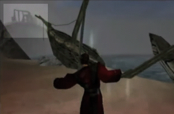
The Ruins seen from the beach in the Gameplay Trailer from 2000.
But at September 12th 2024 when I finally analysed the evolution of the northern environment further in form of the document at hand, to solve the various problems and conflicts I had with this area, it dawned on me, that there could be a third solution. A solution by which the temple could remain at its position and still not be in the way and corrupt the atmosphere and look of the lake. Because when the lake would be high up in the mountains close to the EP, behind the hole on the plateau, it would easily solve all of the problems that I had with Ruins before.
In my prior modeling attempts I hadn’t considered the rise of the terrain yet, because I saw the way up towards the cliff as a sufficient realisation of this idea. But by radically transforming the mountain terrain itself into the northern forest to solve the problem of the Cliff, the Exchange Place, the northern lake and the northern forest together, I realised that the lake behind the forest would be placed so much higher than I had placed it before (just at the level of the pre-alpha versions), that it would be over the level of the temple ruins.
In this case, at least parts of the rock faces west of the temple ruins could remain and the water would run down north and probably south of it too into the ocean; from above, on the lake, the temple would not be seen, just some rocks sticking out from the wall, that the water would flow around; from above the player wouldn’t know about the temple. And from the bottom, the beach and the monastery itself, you couldn’t look upon the lake, but the mountainous region would be preserved, maybe not as high as before, but that really didn’t matter, as unfinished as this area was even in the release version of the game.
Through this solution I could finally solve the puzzle of redesigning the northeastern environment without compromises. I had worked on this design, on and off, in search for a solution, for 2 years.